Serving Clovis, Portales and the Surrounding Communities

'Everybody was freaking out'

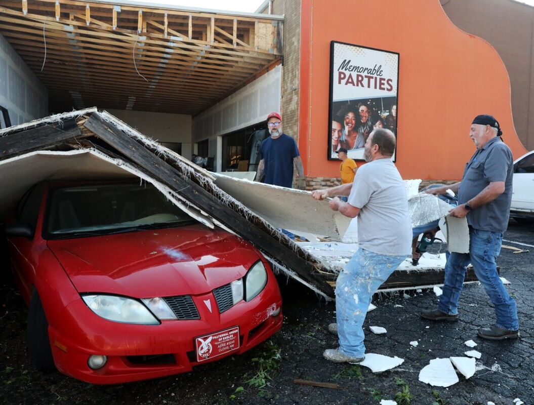
High winds, hail bring damage across region

Margaret Padilla was taking a break from Bingo with family and friends outside Clovis' Red Arrow on Wednesday night.

That's when sprinkles began, about 7:45 p.m. Then the hail hit.

Padilla rushed inside where Red Arrow staff directed the Bingo players to a more central room in the building. They stayed there for 15 or 20 minutes while ice the size of hen eggs was thrown up against the building by winds estimated as high as 70 to 80 mph.

The hail was hitting the ceiling so hard, she said, the white on the tiles started to fall.

"Everybody was freaking out, saying it was snowing in there," Padilla said.

It was no snow storm. Just spring on the High Plains, grabbing headlines for the first time this year, with three confirmed tornadoes in the region and destruction from Quay to Roosevelt counties.

Padilla's father, who is 82, lost his car to the storm when a wall to a Red Arrow storage unit collapsed on it.

Windows, trees, rooftops take a beating

No one was reported injured, but Wednesday's supercell thunderstorm dumped more than 3 inches of rain across eastern New Mexico and left hundreds of area residents with broken windows and trees and damaged rooftops and vehicles.

Tornadoes were reported 4 miles south-southwest of Wheatland, 2-3 miles east-northeast of Grady and 11 miles northwest of Pleasant Hill, according to Jennifer Shoemake, a meteorologist with the National Weather Service in Albuquerque.

No damage was reported from any of the twisters, Shoemake said.

Plenty of damage was reported from hail, high winds and flooding throughout the area.

Shoemake said the largest hail stone reported was tennis ball size near Causey. Clovis, Grady and Texico all reported egg size hail.

The strongest wind gust from Wednesday's storm was recorded at Grady – 92 mph. Cannon Air Force Base reported an 83-mph wind gust, Shoemake said.

The most rain reported to NWS from Wednesday was 3.15 inches at Ned Houk Park north of Clovis. The city of Clovis reported 2.65 to 2.75 inches, Causey collected 3 inches of rain and Portales reported 3/4 of an inch to 1.5 inches.

More rain expected this week

Forecasters expected more rain Friday and through the weekend with some storms expected to be severe.

A chance of rain is forecast for most days this week with high temperatures expected in the mid-70s to mid-80s.

Part of the region received an additional inch of rain overnight Thursday, temporarily closing at least three rural roads in Curry County and leaving many others damaged and hazardous.

Power was out across part of Clovis on Wednesday night and Thursday morning. All of Tucumcari was without power until early afternoon Thursday.

Tornado sirens blared in Grady and Farwell on Wednesday night and at least one twister was photographed by Adam Lucio, a Dallas-area storm chaser who caught it near Grady north of Clovis.

The Clovis Police Department reported power lines were down, street lights were damaged and streets were flooded late Wednesday night. Tree limbs littered the roads.

Social media reports provided additional evidence of the damage.

Deanna Finch of Clovis said her neighbor's tree was in her swimming pool Thursday morning.

The Grady Baptist Church had multiple windows knocked out.

Julie Olufson, who lives near Tiffani and Fred Daugherty in Clovis, said, "We had a raging river next to our house."

Trampoline takes 100-yard trip

Roosevelt County Sheriff Javier Sanchez said he received reports that four utility poles were knocked over during the storm. One of those downed poles blocked Oasis Road, but Sanchez said all county roads were open by Thursday morning.

"I got a call from a lady (Wednesday) night that had about golf ball size hail," Sanchez said. "But she said that her trampoline ripped through her yard and over her roof, over some trees and went about 100 yards down the road."

Dan Heerding, the Clovis/Curry County emergency management director, said he saw five pivot sprinklers flipped near State Road 288 and County Road N.

Most of the areas where tornadoes were confirmed were in "a lot of 'no man's land,'" Heerding said.

The greater damage Heerding saw was in Clovis' city limits.

"You can really see damage on Prince Street: The Wendy's sign is shattered, two traffic signals at Prince Street and the North Plains Mall entrance (were damaged)," he said.

Heerding and other city officials were asking residents to set debris from the storm on the curbs rather than placing it in dumpsters.

"City crews will be by in the next few days to pick up," Heerding said.

Thursday night and Friday morning also brought heavy rains to part of the region, but without the hail and high winds.

The National Weather Service reported a weather station 13 miles north of Texico recorded 2.65 inches of rain overnight Thursday-Friday. The rest of the area saw a quarter-inch of moisture to an inch or more overnight.